Posts

Staying in the wheelhouse of snow potential for a while, coldest air in decades possible next week

Image
 Exact timing and amounts of potential snowfall remain uncertain over next few days.  At this point roads shouldn't be impacted for Christmas eve dinner plans, with most of the wet snow threat tomorrow morning and limited to the highest hills, but Christmas morning could be dicey with colder air and potentially more precipitation. Let's start with tonight.  Cold air will be a trickle, but showers may increase.  With snow levels lowering from ~2000ft to ~1000ft, possibly impacting the highest foothills overnight into Christmas eve morning. I wouldn't be surprised if we have something a bit less impactful than this past Monday (20th).  Trace - 1" for areas like Eagle Pointe, Wilderness Rim. Christmas eve day I think we may be on the northern edge of a faster moving low pressure system.  But this will serve to pick up the Fraser outflow bringing temps down markedly, beginning up North with Bellingham in W. WA.  Again, most of the precipitation looks to be...

Bomb cyclone brings first October gap windstorm in years. A stronger one is on tap for Sunday!

Image
We are more than a month early from our usual Cascadia windstorm season.  In the three fall/winter seasons I've kept records of these windstorms (>= 40 mph).  The earliest in the season was on a Dec 1st (2019). And if my memory serves me, this is the earliest in the 13 years I’ve lived in Snoqualmie. Oct 21st - wunderground station KWASNOQU33 These winds don't usually show up until we get much colder (higher pressure) in E. Washington, then run-of-the mill frontal lows off the coast can easily trigger the push through the mountain gaps.  While we didn’t have the super chilled E. WA, we had an extremely low pressure center off the coast. We'll be keeping a close eye on Sunday's potential action for higher wind gusts than what we've seen today.  In the meantime, periods of boring old light/moderate rain tomorrow morning, hopefully breaking up before another unimpressive front moves through at least the first part of Saturday. Bomb cyclone #2 on Sunday.  Cl...

Near record chill in first half of October. Harbinger for the coming Winter?

Image
Warmer for a change!  On Saturday, several locations around Snoqualmie Valley reached 70°, in stark contrast from the first half of October, that clocked in an average high of about 57°.  Possibly right there with the record lowest average official high of 56.7° set in 1913 at Snoqualmie Falls (depending on differences in exact location, weather instrument accuracy, sun exposure, etc.- then and now). So the question making the rounds in the weather media the last week or so - Does a really cold start to October foretell a cold fall/winter season ahead?   Looking back at local data (station: Snoqualmie Falls) that was available for 122 years (1898-2010) shows the answer is .. not so much.  I looked at the coldest average high for 1H Octobers and worked upwards in rank until I had at least an n=30 (years). What I found was the coldest ~15th percentile bucket of first-half Octobers (calendar days 1st-15th) do not appear to show statistical significance in forecast...

The Week Ahead - Spring Feelings ?

Image
A relatively mundane week ahead, though some models keep playing with a brief warmup mid-week.  Which many folks, admittedly myself included, have been longing for. We should remain dry though mostly overcast, Sunday and most of the day Monday, before some light rain looks to move back into Western Washington Monday evening into early Tuesday.  However, some of the ensembles have turned even drier, with perhaps only a sprinkle with the bulk of the moisture moving to the southwest of us. We begin to really widen the daily temperature ranges with the sun now up over 12 hours as we close in on the Spring Equinox in three weeks.  While Lows look chilly (in the low 30°s) Tuesday and Wednesday morning, a warm front makes its way through, warming Highs into the upper 50°'s, and even possible hitting 60° by Thursday.   weather.us The warmth is expected to be brief however.   A more organized system is expected next weekend, likely bringing a return of widespre...

The Week Ahead - Warm Front Feelings and Cold Flirtations

Image
  windy.com The southern portion of a so-called Atmospheric River begins to impact Washington state on Sunday. Expect showers to begin after 2pm.  A lack of east winds through the passes should allow for warming temperatures through the afternoon, which has already caused precipitation to change over to a rain/snow mix at Snoqualmie Pass.  Avalanche control has seemed to be an ongoing theme at Snoqualmie Pass lately.  Be sure to check pass conditions if you head over the pass this week. It has been an epic snow year indeed!  Back at home I know many folks are still repairing and cleaning up from the major Feb 13th gap wind storm. Taking a closer look, that windstorm was right up there with the big ones measured by pressure gradient between Yakima-Seattle (YKM-SEA), a whopping 13.7 mb!  30 ms = 67 mph (the 2/13 peak gust) Keep us tuned in! We take a high interest level in forecasting the timing and accuracy of these wind events, and are usually first warnin...

Snow is on the way! If it isn't gobbled up..

Image
Snoqualmie Valley/ central Cascade foothills Thursday PM-Friday AM: Snow potential - models are diverging for the above time period, but this isn't the main event.  The NAM model has a Low making landfall even further south (Lincoln City-Eugene OR swatch) than what was projected in earlier model runs yesterday.  If NAM wins out, we remain bone dry.  If the Low path follows the Euro model projection, we'll see a dusting-2" in the central foothills. Snow level expected near sea level with the cold air so your altitude matters less than during wet snow events.  Snow totals we forecast are smaller than advertised by the media due to the gap winds expected to eat/evaporate some of the falling snow. Winds - models are converging on gap winds from the east to begin Thursday late AM/early PM to reach peak gust potential (~30-40 mph) from 6pm to midnight and remain gusty through the day on Friday. Friday PM-Saturday AM: Bigger snow (and Wind) potential - Friday PM through Sat...

The Week Ahead - Post game Snow show??

Image
Sunday will certainly feel chillier as colder air had begun to filter in.  The central Cascades, where a Winter Storm Warning is still in effect, may continue see periods of heavy snowfall into the evening hours. Foothills/Snoqualmie Valley: A convergence zone is expected to form, enhancing precipitation potential for a few hours later this evening.  It still looks like there's fairly good southerly flow aloft so it may come in a bit too warm for snow, but the heavier showers are known to at least temporarily bring the snow level down (~500ft). The GFS model is showing a more favorable setup for this. I'd say there's a 50% chance some might see snowflakes by the tail end of the Super Bowl tonight, or later into the evening (after 8-10 pm), potentially lasting into the overnight hours. But that’s the crux of it.  For the last several days we've seen the GFS model persistently call for a fair amount of snowfall in the foothills, tonight and over the coming days, while the...

The Week Ahead - Phantom Snowflakes ?

Image
Why do the snowflakes on the phone app keep appearing then disappearing.. ?  There were three days of snow forecasted yesterday (Snoqualmie) ?!?  Well there's been a real back and forth with the model runs, but what hasn't really changed is that were only getting fringe temperatures, meaning iffy potential for wet snow for the foothills, and a much lower chance for points westward below 500 ft this week. We're looking at rather steady rains Monday.  Showers look to continue into Tuesday and the early morning hours could be rather windy for a short 2-4 hour period if a weak Low develops with ideal placement over B.C.   A couple model runs have the air mass aloft cooling enough to bring a chance of snowflakes below 1,000 ft Tuesday afternoon into early Wednesday.  Something to keep an eye on, but not looking like much of a threat at this point. A brief break in the action looks likely Wednesday afternoon before more rain dives into the forecast for Thurs...

The Week Ahead - Wishful for snow? Probably not for the round of gap winds set to return.

Image
Too warm and too little precipitation seems to be the story for those hoping to see some real snow anytime soon.  With school out Monday in the SVSD it may be an opportune time for a little of the white stuff. Current radar (1/24 3:45pm) - AccuWeather Early Monday temperatures and precipitation chances (very light if any) look to be a near repeat to last night.  We can't rule out a dusting above 500ft, but the chances look low at this point. We're just not seeing the building cold air out of B.C. like we saw with last year's Janmageddon storm that dropped 15-20" of snow around the Snoqualmie Valley in mid-January 2020. @seattlewxguy (on Twitter) snoqualmiewx.blogspot.com/ Tuesday we look to shift out of the pattern of calm northerly flow we've been having for more than a week as a more significant Low develops out in the Pacific, bringing a return of gap winds with gusts likely to peak ~40-50 mph Tuesday evening.  We aren't likely to see much if any precipitati...

"Sneak Attack Windstorm", This Was NOT

Image
CME commodities trading pit, Chicago IL /Associated Press Should we really be relying on one source for our news?  Relating that question to last Wednesday’s wind event, should we be relying on one type of weather model forecast? Far too many in our community were caught by total surprise with Wednesday’s major windstorm that hit the Pacific Northwest. Puget Sound Energy Emergency Coordination Center even called it a Sneak Attack Windstorm.   Damaging southerly winds early Wednesday exceeded 60 mph in many Puget Sound locations, including the Snoqualmie Valley. Top Wind Gusts - Snoqualmie Ridge (2020/21): The problem is we’re too often fed one baseline forecast that is all encompassed by the mucky law of averages with little awareness of the standard deviation of possibilities from the mean.  Unless your confidence interval is extremely high, only forecasting a wind gust range of say 30-35 mph when there are other models (and very good ones at that) saying 60+ mph, c...

The Week Ahead - Losing Count

Image
Sunday and most of Monday appear to be the relative calm before the storm(s) mid-week.  Should be dry with partly to mostly cloudy skies today.  For Monday, models are mixed as to whether a weak disturbance brings lighter rain back into the forecast, or we may stay mostly dry during the daylight hours. But the real action looks to move in Tuesday and Wednesday.   I’ve lost count on the number of storms centers that tease our state, but drift northeast into B.C.  Close enough to kick up gap winds caused by the Low pulling over Higher pressure east of the Cascades.  Well this looks to be partly the case again Tuesday, though as of now the foothills should be positioned under more of a SE-NW gradient, and much quicker progression.  More characteristic of lower gap wind gusts followed by gusty and rainy widespread conditions across much of Western Wa., not the persistent howling from the east.  Wednesday is where things look a bit different for a change. E...

The Week Ahead - Rain, Wind, Snow, Rain..What's Next ?...

Image
A very active 24-hours of weather we've had, indeed!  ~3" of rain, near 40 mph wind gusts, followed by wet snow - bringing 1-2" in some of the foothill elevations last night before changing back over to rain this morning.   Credit: Ben Tarkington, 12:30 am Sunday @ 870ft elevation (Snoqualmie Ridge) I feel for the poor souls that were stuck for hours at the pass last night :( NWS has extended a Winter Storm Watch for Snoqualmie pass through most of Monday, still snowing hard at times up there! The Snoqualmie River is running high (~14k cfs) near the falls this morning but is not expected to reach flood stages.  Those levels still make for an excellent stop at the visitors center to witness this awesome force of nature! This next week (3rd-10th) looks to bring more active weather. For Sunday the story should be lingering showers, in the 30's but rising to low-mid 40's by mid afternoon. Overnight we should see easterly winds pick up through the Cascade gaps (~30-40 ...

The Week Ahead - New Year In Sight

Image
EaglePointe neighborhood, Snoqualmie Ridge (elev ~1,100ft ) -  Christmas Eve While most seem anxious for what 2021 will bring, in the short run it would appear more of the same, and that includes the weather pattern.    A chance of light rain Sunday morning as a weak front moves northward, though most of the precipitation should be to the west of us.  We should then get some clearing later in the day as high pressure begins to build in.  However, it does appear we have another round of moderate Cascadia (gap) winds to get through ~25-35 mph this evening as an E-W pressure gradient sets up shop.  This one is a bit more NE-SW oriented, so areas to the north susceptible like Gold Bar may see a bit stronger winds than us this go around. Winds should dissipate after midnight and we'll be left with relatively clear skies with areas dropping below freezing, if not early Monday, very likely early Tuesday.  We should see rather sunny skies, outside of areas of ...

Colder Air (and Snow??) Imminent!

Image
After a record setting 61° for winter solstice, we’re watching the stark rain-snow line make it’s way southeast this afternoon into evening.   A dramatic temperature drop is imminent! This is a tricky one indeed... While earlier model runs had pointed to sparse remaining moisture tonight, there’s now better model consensus that shower activity should hang around long enough to possibly see some wet flakes tonight as precipitation mixes with this incoming cooler air.  We’re not talking a freeze or icy conditions, but we can’t rule out some wet snow accumulations. So here’s the no guts no glory snow forecast- (dividing this into hilltops of Eagle Pt, Wilderness Rim ~1000 ft, and lower elevations of Snoqualmie/North Bend ~500 ft Best window for snow 6pm-midnight  @ 1000ft  -visible snowflakes, odds 60% -dusting, odds 50% -1-3”, odds 35% (rooftops and lawns) @ 500 ft -visible snowflakes, odds 50% -dusting, odds 40% -1-3”, odds 20% (rooftops and lawns) Lastly, roads are v...

The Week Ahead - Snowflakes Before Christmas ??

Image
Many out here remember the epic December snow and White Christmas of 2008, but do you remember 2017?   White Christmas 2017 Looking west at The Heights neighborhood, Snoqualmie Ridge (from Douglas Ave SE & SE Carmichael St)  For the week ahead: After another rainy Saturday that became blustery last night, we're trying to dry out this morning, in between weather systems for much of Sunday before steadier rain returns late tonight.  The mountains will be battling between rain and snow, but snowpack melt looks minor and little potential threat for river flooding at this point. As previously mentioned, another front looks set to move in later tonight into Monday bringing another good dose of rain, heavy at times Monday morning that should gradually decrease in the afternoon and evening.  Models are mixed currently as to whether or not we'll see another round of southerly winds develop Monday afternoon. Now is where things get more interesting.. An upper trough a...

The Week Ahead - Much Wetter, Winds of Some Kind May Return

Image
Waking from another sleep disrupted gap wind event Saturday night. zzz :(  We typically get 6-10 of these Cascadia (gap) wind events that produce significant winds (tallied if peak gusts on Snoqualmie Ridge reach at least 40 mph) per fall/winter season.   We're already at four!   2020-21 Here's how the last couple windstorm seasons compared... 2019-20 2018-19 Further back, an 80 mph gap wind event in December 2003 was the closest we got this millennium to the monster  gap windstorm of the last century The week ahead -- Otherwise, rain has spread into the Puget Sound area Sunday. What precipitation wasn't getting eaten by these dry east winds was mixing briefly with snow down to around 500-1,000 feet early Sunday morning, but further threat should be short-lived as winds shifting more southerly this afternoon will bring warmer air aloft.  Light rain otherwise into Sunday night.  With the snow level still around 2,000 feet, a few inches of snow can ...

What a Windy Week! Now Something Mysterious May Fall From the Sky

Image
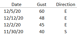
Wow what a week!  All that wind with not much rain! We had three strong rounds of winds, each with a peak gust at or exceeding 40 mph 11/30 -      40 mph     S     Precip = 0.5" 12/02 -      45 mph     E     Precip = 0.0" 12/05-       60 mph     E     Precip = 0.0" I like to track the windstorms that hit the Snoqualmie Valley area (most are gap winds from the east) which clock a peak gust at or above 40 mph.  Usually 6-8 per fall/winter season, with the bulk after New Years; when E. WA gets super cold and we get some really good pressure differences with storms off the coast.   We're already at three!  The most damaging of which was Saturday morning, bringing down trees and fences.  The peak gusts didn't last long, but were ferocious.  Wunderground weather station Watch Got to squeeze more pain into 2020 I guess, am I right .. ?!?...

The Week Ahead - Basking in Morning Sun

Image
While much of the Puget Sound lowlands will be socked in by fog with stagnant cold air, the Cascade foothills are waking up Sunday to relatively warmer conditions in the mid 40°'s and mostly clear skies. You can thank light easterlies (gap winds) in response to an incoming front off the coast (shouldn't impact us until overnight into Monday). Clouds should begin to increase this afternoon and evening as a cold front approaches. Expect winds to shift overnight, blustery at times from the S/SW with rainy conditions Monday morning.  What may begin as rain at Snoqualmie Summit, should change over to snow as air aloft continues to cool, ushered through by this system.  Accumulations look to be on the light side; a couple inches up to 6" of new snow possible.  For the lowlands, showers should taper off by late Monday morning or early afternoon for most.  A convergence zone over the northern Sound may then develop into Monday evening.  These usually hold the potential ...

The Week Ahead - The Thanksgiving Forecast

Image
We've seen a good round of light to moderate gap winds (expected to die out Sunday morning) in the foothills ahead of an incoming weak cold front Sunday night into Monday that should deliver light rain in the Valley and light snow at Snoqualmie pass (accumulations ~1-4"). The next more organized front should arrive Tuesday evening into Wednesday, bringing rain with potentially onshore breezy conditions to the foothills.  Snoqualmie Pass looked to be more on the bubble between rain and now with earlier model runs, but 2-8" of snow looks more likely now.  Even in those slightly warmer scenarios, nothing suggested a significant warming and/or heavy rain to cause much if any melt off of existing accumulations. Looking out longer term for Thanksgiving, lingering showers look likely for the lowlands and light snow/flurries in the mountain passes.  famersalmanac.com The remainder of the coming week (Friday-Sunday) looks rather uncertain, but odds are currently in the c...

The Week Ahead - Watching Another Potential Windstorm, Snow Levels to Rise (briefly)

Image
ECMWF model forecasted wind gusts for Tuesday AM (windy.com) After a stormy Saturday night, Sunday looks to extend that experience somewhat with rain turning to showers but gusty conditions continue at times.  Winds are transitioning from easterlies to southerlies, which should bring in a little warmer air aloft and snow levels to rise above Snoqualmie Pass for the first part of this week. Hopefully much better travel across the state compared to Friday and Saturday. We might actually exceed normal highs for this time of year (~50°), ever so briefly.  We had been running 5-10° below normal the past week bringing an early snowpack to our ski resorts!   That snow doesn't look to be going anywhere during the early week brief warmup as we then begin to cool back below normal for the remainder of the week, albeit with less precipitation potential for new snow. Highs (magenta), Lows (blue), Actual temp (red) University of Washington, Department of Atmospheric Sciences But...