Posts

Showing posts from January, 2021

The Week Ahead - Phantom Snowflakes ?

Image
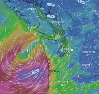
Why do the snowflakes on the phone app keep appearing then disappearing.. ?  There were three days of snow forecasted yesterday (Snoqualmie) ?!?  Well there's been a real back and forth with the model runs, but what hasn't really changed is that were only getting fringe temperatures, meaning iffy potential for wet snow for the foothills, and a much lower chance for points westward below 500 ft this week. We're looking at rather steady rains Monday.  Showers look to continue into Tuesday and the early morning hours could be rather windy for a short 2-4 hour period if a weak Low develops with ideal placement over B.C.   A couple model runs have the air mass aloft cooling enough to bring a chance of snowflakes below 1,000 ft Tuesday afternoon into early Wednesday.  Something to keep an eye on, but not looking like much of a threat at this point. A brief break in the action looks likely Wednesday afternoon before more rain dives into the forecast for Thursday, with showers ling

The Week Ahead - Wishful for snow? Probably not for the round of gap winds set to return.

Image
Too warm and too little precipitation seems to be the story for those hoping to see some real snow anytime soon.  With school out Monday in the SVSD it may be an opportune time for a little of the white stuff. Current radar (1/24 3:45pm) - AccuWeather Early Monday temperatures and precipitation chances (very light if any) look to be a near repeat to last night.  We can't rule out a dusting above 500ft, but the chances look low at this point. We're just not seeing the building cold air out of B.C. like we saw with last year's Janmageddon storm that dropped 15-20" of snow around the Snoqualmie Valley in mid-January 2020. @seattlewxguy (on Twitter) snoqualmiewx.blogspot.com/ Tuesday we look to shift out of the pattern of calm northerly flow we've been having for more than a week as a more significant Low develops out in the Pacific, bringing a return of gap winds with gusts likely to peak ~40-50 mph Tuesday evening.  We aren't likely to see much if any precipitati

"Sneak Attack Windstorm", This Was NOT

Image
CME commodities trading pit, Chicago IL /Associated Press Should we really be relying on one source for our news?  Relating that question to last Wednesday’s wind event, should we be relying on one type of weather model forecast? Far too many in our community were caught by total surprise with Wednesday’s major windstorm that hit the Pacific Northwest. Puget Sound Energy Emergency Coordination Center even called it a Sneak Attack Windstorm.   Damaging southerly winds early Wednesday exceeded 60 mph in many Puget Sound locations, including the Snoqualmie Valley. Top Wind Gusts - Snoqualmie Ridge (2020/21): The problem is we’re too often fed one baseline forecast that is all encompassed by the mucky law of averages with little awareness of the standard deviation of possibilities from the mean.  Unless your confidence interval is extremely high, only forecasting a wind gust range of say 30-35 mph when there are other models (and very good ones at that) saying 60+ mph, clearly this isn’t e

The Week Ahead - Losing Count

Image
Sunday and most of Monday appear to be the relative calm before the storm(s) mid-week.  Should be dry with partly to mostly cloudy skies today.  For Monday, models are mixed as to whether a weak disturbance brings lighter rain back into the forecast, or we may stay mostly dry during the daylight hours. But the real action looks to move in Tuesday and Wednesday.   I’ve lost count on the number of storms centers that tease our state, but drift northeast into B.C.  Close enough to kick up gap winds caused by the Low pulling over Higher pressure east of the Cascades.  Well this looks to be partly the case again Tuesday, though as of now the foothills should be positioned under more of a SE-NW gradient, and much quicker progression.  More characteristic of lower gap wind gusts followed by gusty and rainy widespread conditions across much of Western Wa., not the persistent howling from the east.  Wednesday is where things look a bit different for a change. Euro model Wed 1/13 10 am Per the E

The Week Ahead - Rain, Wind, Snow, Rain..What's Next ?...

Image
A very active 24-hours of weather we've had, indeed!  ~3" of rain, near 40 mph wind gusts, followed by wet snow - bringing 1-2" in some of the foothill elevations last night before changing back over to rain this morning.   Credit: Ben Tarkington, 12:30 am Sunday @ 870ft elevation (Snoqualmie Ridge) I feel for the poor souls that were stuck for hours at the pass last night :( NWS has extended a Winter Storm Watch for Snoqualmie pass through most of Monday, still snowing hard at times up there! The Snoqualmie River is running high (~14k cfs) near the falls this morning but is not expected to reach flood stages.  Those levels still make for an excellent stop at the visitors center to witness this awesome force of nature! This next week (3rd-10th) looks to bring more active weather. For Sunday the story should be lingering showers, in the 30's but rising to low-mid 40's by mid afternoon. Overnight we should see easterly winds pick up through the Cascade gaps (~30-40