The Week Ahead - Much Wetter, Winds of Some Kind May Return
Waking from another sleep disrupted gap wind event Saturday night. zzz :(
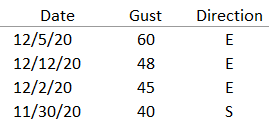
We typically get 6-10 of these Cascadia (gap) wind events that produce significant winds (tallied if peak gusts on Snoqualmie Ridge reach at least 40 mph) per fall/winter season.
We're already at four!
2020-21
Here's how the last couple windstorm seasons compared...
2019-20
An active weather pattern is expected through much of this next week.
Models are mixed whether we get much if any dry out Monday before another front will move in Tuesday for rain, breezy winds, and mountain snow. Snow levels with the Tuesday system around 2500-3500 feet for additional snow for the Passes. A brief break possible on Wednesday, though some precipitation still may be around as the trough slides east. The active pattern is expected to continue late week and into the weekend. Southerly winds could be quite strong for parts of next weekend as a significant Low looks to set up shop in British Columbia.
Have a great week!


Comments
Post a Comment