Posts

Showing posts from November, 2020

The Week Ahead - Basking in Morning Sun

Image
While much of the Puget Sound lowlands will be socked in by fog with stagnant cold air, the Cascade foothills are waking up Sunday to relatively warmer conditions in the mid 40°'s and mostly clear skies. You can thank light easterlies (gap winds) in response to an incoming front off the coast (shouldn't impact us until overnight into Monday). Clouds should begin to increase this afternoon and evening as a cold front approaches. Expect winds to shift overnight, blustery at times from the S/SW with rainy conditions Monday morning.  What may begin as rain at Snoqualmie Summit, should change over to snow as air aloft continues to cool, ushered through by this system.  Accumulations look to be on the light side; a couple inches up to 6" of new snow possible.  For the lowlands, showers should taper off by late Monday morning or early afternoon for most.  A convergence zone over the northern Sound may then develop into Monday evening.  These usually hold the potential of drifting

The Week Ahead - The Thanksgiving Forecast

Image
We've seen a good round of light to moderate gap winds (expected to die out Sunday morning) in the foothills ahead of an incoming weak cold front Sunday night into Monday that should deliver light rain in the Valley and light snow at Snoqualmie pass (accumulations ~1-4"). The next more organized front should arrive Tuesday evening into Wednesday, bringing rain with potentially onshore breezy conditions to the foothills.  Snoqualmie Pass looked to be more on the bubble between rain and now with earlier model runs, but 2-8" of snow looks more likely now.  Even in those slightly warmer scenarios, nothing suggested a significant warming and/or heavy rain to cause much if any melt off of existing accumulations. Looking out longer term for Thanksgiving, lingering showers look likely for the lowlands and light snow/flurries in the mountain passes.  famersalmanac.com The remainder of the coming week (Friday-Sunday) looks rather uncertain, but odds are currently in the camp of a w

The Week Ahead - Watching Another Potential Windstorm, Snow Levels to Rise (briefly)

Image
ECMWF model forecasted wind gusts for Tuesday AM (windy.com) After a stormy Saturday night, Sunday looks to extend that experience somewhat with rain turning to showers but gusty conditions continue at times.  Winds are transitioning from easterlies to southerlies, which should bring in a little warmer air aloft and snow levels to rise above Snoqualmie Pass for the first part of this week. Hopefully much better travel across the state compared to Friday and Saturday. We might actually exceed normal highs for this time of year (~50°), ever so briefly.  We had been running 5-10° below normal the past week bringing an early snowpack to our ski resorts!   That snow doesn't look to be going anywhere during the early week brief warmup as we then begin to cool back below normal for the remainder of the week, albeit with less precipitation potential for new snow. Highs (magenta), Lows (blue), Actual temp (red) University of Washington, Department of Atmospheric Sciences But the real activ

The Week Ahead - Turning Wet with Mountain Snow, and Maybe a Windstorm..?

Image
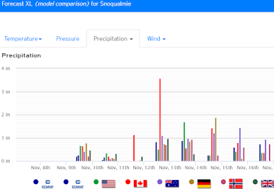
It's been a chilly but at least sunny start to Sunday, however wet weather looks set to return this week.  With h ighs likely to run 5-8°F below normal for early November in Snoqualmie Valley,  we should see chilly rains in the lowlands  and mountain snow down to all pass levels.   weather.us Northerly flow should turn more onshore on Monday.  A cool showery pattern should be associated with an initial front late Monday into Tuesday. Wednesday and possibly early Thursday should see some break from the rain, before a more significant system moves in later Thursday into Friday .  Some earlier model runs had a significant Low barreling through northern WA or southern BC, with the potential to set up a 12-15 mb pressure gradient between Portland and Seattle.  We'll keep an eye out!  This would be cause for major concern as far as potential for widespread damaging winds (50+ mph) and power outages to the Puget Sound area.  However, looking at longer range model runs this doesn't

The Week Ahead - Enjoy some November sunshine while it lasts!

Image
Moonrise over Cascades, seen from Snoqualmie Oct. 29 The next full moon on Halloween won't be until 2039! After a chilly start today and an extra hour to play with, Sunday and Monday will provide exceptional weather to break down and store away all the ghosts, goblins and candy chutes.  Highs will be running  ~10° above normal, in the  low-mid 60's ! Tuesday features a transition day, as the first of a series of three frontal systems looks set to move through bringing periods of rain and wind until Saturday. On the first approach Tuesday, Higher pressure conditions east of the mountains may kick off some moderate but brief gap winds (~20-30 mph) as that air rushes through the Cascade gaps to mix with Low pressure associated with the front coming onshore.  Early Thursday looks to be a more traditional rainy and breezy period with gusts from the S/SW to ~30 mph.  Snow levels during the work week may work their way down to ~4000 ft, but well above Snoqualmie Pass and borderline