The Week Ahead - Losing Count
But the real action looks to move in Tuesday and Wednesday.
I’ve lost count on the number of storms centers that tease our state, but drift northeast into B.C. Close enough to kick up gap winds caused by the Low pulling over Higher pressure east of the Cascades. Well this looks to be partly the case again Tuesday, though as of now the foothills should be positioned under more of a SE-NW gradient, and much quicker progression. More characteristic of lower gap wind gusts followed by gusty and rainy widespread conditions across much of Western Wa., not the persistent howling from the east.
Wednesday is where things look a bit different for a change.
 |
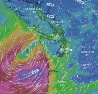
| Euro model Wed 1/13 10 am |
Per the Euro model baseline ensembles, a Low looks to track right into the Puget Sound region. However, at this point it doesn’t look very deep. The key will be the developing Low but also the tracking S-N pressure gradient as to whether Western WA will get some damaging southerly winds out of this.
Longer range, nothing special is currently apparent. Thursday may be a dry day after the Tues-Wed action, followed by another mundane round of rain Friday. Shower possible into next weekend, but with more potential dry periods.
Rising snow levels look to be a factor Tuesday and Wednesday as we look to draw in significant moisture from the southwest. As of now it looks like just as much rain as snow for the lower elevation passes (e.g. Snoqualmie Summit)..:(
Have a great week!
What is your opinion of how our local weather may be impacted by the Polar Vortex split that has been in the news lately?
ReplyDelete"Polar Vortex" is a great catch phrase for the media to really hype on for the severity of cold air dropping down over more typically temperate climate zones. When in reality these vortices are more typical cold extensions of the grander circulation patterns. They often drop down over oceans, but only make news when making landfall. Locally, I see signs of some moderate cooling out past Jan 20th, but I've learned not to lean to heavily on these longer range forecasts, vortex or not. :)
ReplyDelete