Posts

Showing posts from 2020

The Week Ahead - New Year In Sight

Image
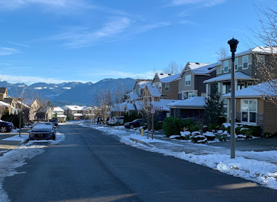
EaglePointe neighborhood, Snoqualmie Ridge (elev ~1,100ft ) -  Christmas Eve While most seem anxious for what 2021 will bring, in the short run it would appear more of the same, and that includes the weather pattern.    A chance of light rain Sunday morning as a weak front moves northward, though most of the precipitation should be to the west of us.  We should then get some clearing later in the day as high pressure begins to build in.  However, it does appear we have another round of moderate Cascadia (gap) winds to get through ~25-35 mph this evening as an E-W pressure gradient sets up shop.  This one is a bit more NE-SW oriented, so areas to the north susceptible like Gold Bar may see a bit stronger winds than us this go around. Winds should dissipate after midnight and we'll be left with relatively clear skies with areas dropping below freezing, if not early Monday, very likely early Tuesday.  We should see rather sunny skies, outside of areas of fog that may form, Monday and

Colder Air (and Snow??) Imminent!

Image
After a record setting 61° for winter solstice, we’re watching the stark rain-snow line make it’s way southeast this afternoon into evening.   A dramatic temperature drop is imminent! This is a tricky one indeed... While earlier model runs had pointed to sparse remaining moisture tonight, there’s now better model consensus that shower activity should hang around long enough to possibly see some wet flakes tonight as precipitation mixes with this incoming cooler air.  We’re not talking a freeze or icy conditions, but we can’t rule out some wet snow accumulations. So here’s the no guts no glory snow forecast- (dividing this into hilltops of Eagle Pt, Wilderness Rim ~1000 ft, and lower elevations of Snoqualmie/North Bend ~500 ft Best window for snow 6pm-midnight  @ 1000ft  -visible snowflakes, odds 60% -dusting, odds 50% -1-3”, odds 35% (rooftops and lawns) @ 500 ft -visible snowflakes, odds 50% -dusting, odds 40% -1-3”, odds 20% (rooftops and lawns) Lastly, roads are very warm, especiall

The Week Ahead - Snowflakes Before Christmas ??

Image
Many out here remember the epic December snow and White Christmas of 2008, but do you remember 2017?   White Christmas 2017 Looking west at The Heights neighborhood, Snoqualmie Ridge (from Douglas Ave SE & SE Carmichael St)  For the week ahead: After another rainy Saturday that became blustery last night, we're trying to dry out this morning, in between weather systems for much of Sunday before steadier rain returns late tonight.  The mountains will be battling between rain and snow, but snowpack melt looks minor and little potential threat for river flooding at this point. As previously mentioned, another front looks set to move in later tonight into Monday bringing another good dose of rain, heavy at times Monday morning that should gradually decrease in the afternoon and evening.  Models are mixed currently as to whether or not we'll see another round of southerly winds develop Monday afternoon. Now is where things get more interesting.. An upper trough and cold front wi

The Week Ahead - Much Wetter, Winds of Some Kind May Return

Image
Waking from another sleep disrupted gap wind event Saturday night. zzz :(  We typically get 6-10 of these Cascadia (gap) wind events that produce significant winds (tallied if peak gusts on Snoqualmie Ridge reach at least 40 mph) per fall/winter season.   We're already at four!   2020-21 Here's how the last couple windstorm seasons compared... 2019-20 2018-19 Further back, an 80 mph gap wind event in December 2003 was the closest we got this millennium to the monster  gap windstorm of the last century The week ahead -- Otherwise, rain has spread into the Puget Sound area Sunday. What precipitation wasn't getting eaten by these dry east winds was mixing briefly with snow down to around 500-1,000 feet early Sunday morning, but further threat should be short-lived as winds shifting more southerly this afternoon will bring warmer air aloft.  Light rain otherwise into Sunday night.  With the snow level still around 2,000 feet, a few inches of snow can be expected at Snoqualmie P

What a Windy Week! Now Something Mysterious May Fall From the Sky

Image
Wow what a week!  All that wind with not much rain! We had three strong rounds of winds, each with a peak gust at or exceeding 40 mph 11/30 -      40 mph     S     Precip = 0.5" 12/02 -      45 mph     E     Precip = 0.0" 12/05-       60 mph     E     Precip = 0.0" I like to track the windstorms that hit the Snoqualmie Valley area (most are gap winds from the east) which clock a peak gust at or above 40 mph.  Usually 6-8 per fall/winter season, with the bulk after New Years; when E. WA gets super cold and we get some really good pressure differences with storms off the coast.   We're already at three!  The most damaging of which was Saturday morning, bringing down trees and fences.  The peak gusts didn't last long, but were ferocious.  Wunderground weather station Watch Got to squeeze more pain into 2020 I guess, am I right .. ?!?  I haven't seen a gust of 60 mph in several years.  Many that have lived in the area for a couple decades  may recall the mons

The Week Ahead - Basking in Morning Sun

Image
While much of the Puget Sound lowlands will be socked in by fog with stagnant cold air, the Cascade foothills are waking up Sunday to relatively warmer conditions in the mid 40°'s and mostly clear skies. You can thank light easterlies (gap winds) in response to an incoming front off the coast (shouldn't impact us until overnight into Monday). Clouds should begin to increase this afternoon and evening as a cold front approaches. Expect winds to shift overnight, blustery at times from the S/SW with rainy conditions Monday morning.  What may begin as rain at Snoqualmie Summit, should change over to snow as air aloft continues to cool, ushered through by this system.  Accumulations look to be on the light side; a couple inches up to 6" of new snow possible.  For the lowlands, showers should taper off by late Monday morning or early afternoon for most.  A convergence zone over the northern Sound may then develop into Monday evening.  These usually hold the potential of drifting

The Week Ahead - The Thanksgiving Forecast

Image
We've seen a good round of light to moderate gap winds (expected to die out Sunday morning) in the foothills ahead of an incoming weak cold front Sunday night into Monday that should deliver light rain in the Valley and light snow at Snoqualmie pass (accumulations ~1-4"). The next more organized front should arrive Tuesday evening into Wednesday, bringing rain with potentially onshore breezy conditions to the foothills.  Snoqualmie Pass looked to be more on the bubble between rain and now with earlier model runs, but 2-8" of snow looks more likely now.  Even in those slightly warmer scenarios, nothing suggested a significant warming and/or heavy rain to cause much if any melt off of existing accumulations. Looking out longer term for Thanksgiving, lingering showers look likely for the lowlands and light snow/flurries in the mountain passes.  famersalmanac.com The remainder of the coming week (Friday-Sunday) looks rather uncertain, but odds are currently in the camp of a w

The Week Ahead - Watching Another Potential Windstorm, Snow Levels to Rise (briefly)

Image
ECMWF model forecasted wind gusts for Tuesday AM (windy.com) After a stormy Saturday night, Sunday looks to extend that experience somewhat with rain turning to showers but gusty conditions continue at times.  Winds are transitioning from easterlies to southerlies, which should bring in a little warmer air aloft and snow levels to rise above Snoqualmie Pass for the first part of this week. Hopefully much better travel across the state compared to Friday and Saturday. We might actually exceed normal highs for this time of year (~50°), ever so briefly.  We had been running 5-10° below normal the past week bringing an early snowpack to our ski resorts!   That snow doesn't look to be going anywhere during the early week brief warmup as we then begin to cool back below normal for the remainder of the week, albeit with less precipitation potential for new snow. Highs (magenta), Lows (blue), Actual temp (red) University of Washington, Department of Atmospheric Sciences But the real activ

The Week Ahead - Turning Wet with Mountain Snow, and Maybe a Windstorm..?

Image
It's been a chilly but at least sunny start to Sunday, however wet weather looks set to return this week.  With h ighs likely to run 5-8°F below normal for early November in Snoqualmie Valley,  we should see chilly rains in the lowlands  and mountain snow down to all pass levels.   weather.us Northerly flow should turn more onshore on Monday.  A cool showery pattern should be associated with an initial front late Monday into Tuesday. Wednesday and possibly early Thursday should see some break from the rain, before a more significant system moves in later Thursday into Friday .  Some earlier model runs had a significant Low barreling through northern WA or southern BC, with the potential to set up a 12-15 mb pressure gradient between Portland and Seattle.  We'll keep an eye out!  This would be cause for major concern as far as potential for widespread damaging winds (50+ mph) and power outages to the Puget Sound area.  However, looking at longer range model runs this doesn't

The Week Ahead - Enjoy some November sunshine while it lasts!

Image
Moonrise over Cascades, seen from Snoqualmie Oct. 29 The next full moon on Halloween won't be until 2039! After a chilly start today and an extra hour to play with, Sunday and Monday will provide exceptional weather to break down and store away all the ghosts, goblins and candy chutes.  Highs will be running  ~10° above normal, in the  low-mid 60's ! Tuesday features a transition day, as the first of a series of three frontal systems looks set to move through bringing periods of rain and wind until Saturday. On the first approach Tuesday, Higher pressure conditions east of the mountains may kick off some moderate but brief gap winds (~20-30 mph) as that air rushes through the Cascade gaps to mix with Low pressure associated with the front coming onshore.  Early Thursday looks to be a more traditional rainy and breezy period with gusts from the S/SW to ~30 mph.  Snow levels during the work week may work their way down to ~4000 ft, but well above Snoqualmie Pass and borderline

The Week Ahead - Looking mostly dry...until Halloween of course:(

Image
Fall City Farms We've begun a chilly start Sunday with our first frost, but today should still make for a great last dry weekend run to the pumpkin patch ahead of an otherwise quiet Autumn week ahead.    Cool and crisp today with high pressure in place.  Highs should reach mid-40°s. Since 1981, Snoqualmie Valley averages 39 days a year with at or below freezing temperatures vs. an average of 27 per year at Sea-tac airport over the same period. To recap the last couple days, warmer air invaded much of the southern half of Washington on Friday, busting up chances for significant snowfall at Snoqualmie Pass, or to see a few wet flakes here in the foothills.  However, several places in the northern half of the state had a very early glimpse of winter. I was fortunate enough to be in Spokane Friday evening (23rd) to witness their snowiest October day ever (6.2"), breaking a record dating back to 1957. Nothing in E. WA along I-90 until about 40 miles from city limits and temperature

The Week Ahead - October Snow on the Way?

Image
Could this be a similar view for us next weekend (October 24th)?  Very possible! Models aren't saying this is a totally crazy idea. Well...what about this one? Not likely.. Several folks in the weather community the past few days have pointed out that a few GFS ensembles show very chilly temperatures by next weekend (~24th-26th).  While a few model outliers in context of bucking strong seasonal odds (it's only October!) is usually dismissed as 'Fantasy', now the higher resolution Euro model does seem to be in agreement for some kind of major cool down.  Not quite as extreme a forecast, but certainly an eye opener for this time of year.  weather.us All the early buzz is pinned on the likelihood high pressure remains steadfast over the northeastern Pacific, feeding persistent northwest flow down into the Pacific NW  bringing a pattern of unseasonable cool air and weak frontal activity that might just eke out a wet snow shower or two down below pass levels .   While there&

The Week Ahead - Hawks Game Windstorm Possible! And another Tuesday, before drier conditions later in week

Image
We're really transitioning into active Fall-like weather now, aren't we? Saturday in Snoqualmie Valley featured blustery winds with ~2" of rain that mostly fell in the morning.   However, our Puget Sound neighbors to the north were graced by a round 2 dumping, a classic convergence zone (CZ) setup yesterday afternoon that featured hail and thunderstorms.   A few excellent shots were captured by some storm chasers... Seen from Kenmore Saturday afternoon by Michael Snyder @seattlewxguy (on twitter) Let's look at this NWS graphic of vertical heights from one of the more active storm cells over N. Lake Washington yesterday.  Fascinating.  Cells stretching into the higher altitudes were very conducive to the lightning and heavy rain or hail dropped in several locations from the Bothell-area on northward. And given the cool unstable air that ushered in behind the main front Saturday morning, the first snow of the season for some of our higher passes. Now let's look ahead

The Week Ahead - October cool down on the way, enjoy first half of week

Image
By the time of year that October rolls around, with the long nights and much lower sun angle, if the air is relatively stagnant we're very likely going to get FOG.  That's been the story the last few mornings. Friday and Saturday the fog burned off to gorgeous afternoons, but a weak front that brushed us today kept things overcast this afternoon.   Mt. Si Golf Course - Friday afternoon (10/2) Monday we should be back to areas of morning fog, but that should give way to afternoon sunshine.  Same story for Tuesday and Wednesday, with somewhat warmer afternoons that might reach 70°.  I think it's wishful thinking for my tomatoes at this point:(   The bigger change starts to occur in the atmosphere as the upper level ridge moves east mid-week, bringing a more southwesterly flow.  Thursday looks overcast ahead of the next system.   Models had continued to shift back the timing of rain for this coming week, but now appear to be in consensus for meaningful precipitation to begin F

The Week Ahead – Here Come’s the Sun, but will the Smoke Stay Away?

Image
Update: Wednesday 9/30/2020 6:43 am Starting day with better air quality than yesterday.  Light easterlies overnight have kept fog away.  Winds shift this morning and expect the smoke aloft to move overhead by mid afternoon. Mixing to surface light, AQI not expected to exceed moderate (yellow). Original post What a wet start to Autumn. While we didn’t tally anywhere close to the ~8 inch monthly precipitation record (at Snoqualmie Falls) for September, it did rain 4”.  That's the third wettest over any 3-day period in September.  Had it not been for the dry first three weeks of the month we might have threatened the monthly rainfall record.   Now let us talk about the big warmup on the way!   A building ridge of high pressure should dominate, potentially sending highs into the 80°’s by mid-week. With October fast approaching, this does beg the question if we’re going to break any heat records this week.  I was initially surprised by my finding.   Not Likely.  Turns out there was a m

The Week Ahead - Want Rain? Careful What You Wish For

Image
Update - 9/22/20: We're bracing for first major storm of the season as it pushes onshore Wednesday morning.  Lot's of wind and rain.  In fact, per Euro and NAM latest main model runs, I'm upgrading our wind gust prospects Wed afternoon and Fri inland, 30-40 mph+ gusts out of the S/SW possible in Snoqualmie Valley vicinity. With all the leaves still on trees, there may be intermittent power outages.    A second round of atmospheric river should develop over the weekend, keeping things wet.  By weeks end, we're talking potential 5+" of rain for late September! weather.us Longer range still hints and pulling a complete 180° next week with unseasonable warm and sunny weather.  Looking forward to that! Original story - 9/20/20 Now that we've all taken that deep breath of fresh air, more active weather is wasting little time arriving at our doorstep, and just in time for the first week of Autumn.   Autumn begins Tuesday, September 22nd , when the Sun crosses the cele