The Week Ahead - Watching Another Potential Windstorm, Snow Levels to Rise (briefly)
 |
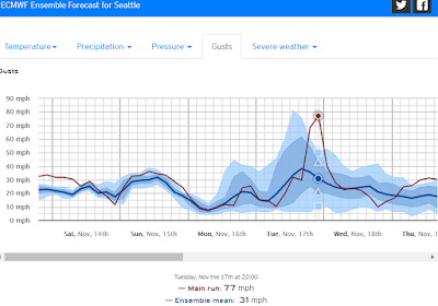
| ECMWF model forecasted wind gusts for Tuesday AM (windy.com) |
After a stormy Saturday night, Sunday looks to extend that experience somewhat with rain turning to showers but gusty conditions continue at times. Winds are transitioning from easterlies to southerlies, which should bring in a little warmer air aloft and snow levels to rise above Snoqualmie Pass for the first part of this week. Hopefully much better travel across the state compared to Friday and Saturday.
We might actually exceed normal highs for this time of year (~50°), ever so briefly. We had been running 5-10° below normal the past week bringing an early snowpack to our ski resorts! That snow doesn't look to be going anywhere during the early week brief warmup as we then begin to cool back below normal for the remainder of the week, albeit with less precipitation potential for new snow.
 |
| Highs (magenta), Lows (blue), Actual temp (red) University of Washington, Department of Atmospheric Sciences |
Contrary to some Saturday model runs (below)..
 |
| Euro model, Saturday 11/14 (am) weather.us |
as of Sunday morning the Low looked to track too far NW for the perfect Seattle wind setup. However, an uncertain main storm track is not the only risk, as Michael Snyder explains. "any secondary low forming on the SE of the main low has a chance to cross close to the region".
You can see (below) that by noon Tuesday how narrow the isobars (representing air pressure difference) are over western Washington, and particularly over the Olympic Peninsula.
If the actual strength of this Low is anywhere close to what is currently forecasted, at the very least Snoqualmie Valley should see a significant gap windstorm (40+ mph) as higher pressure east of the Cascades rushes through the mountain gaps to mix with lower pressure in W. WA. We average half a dozen or so significant gap windstorms per fall/winter season.
We'll be watching this one closely!
For the remainder of the week, Wednesday and Thursday rain showers are likely to persist in the foothills. Models are mixed, but look to lean toward decreasing chance of precipitation Friday into Saturday. Cooler again though, with any precipitation likely to fall as snow at Snoqualmie Pass.
Have a great week!


Comments
Post a Comment