The Week Ahead - Turning Wet with Mountain Snow, and Maybe a Windstorm..?
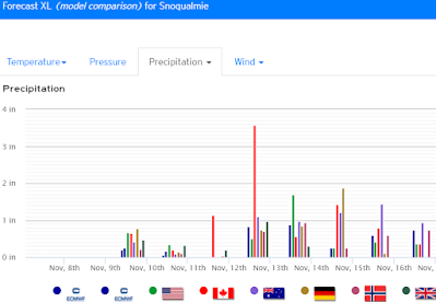
It's been a chilly but at least sunny start to Sunday, however wet weather looks set to return this week. With highs likely to run 5-8°F below normal for early November in Snoqualmie Valley, we should see chilly rains in the lowlands and mountain snow down to all pass levels.
 |
| weather.us |
Northerly flow should turn more onshore on Monday. A cool showery pattern should be associated with an initial front late Monday into Tuesday.
Wednesday and possibly early Thursday should see some break from the rain, before a more significant system moves in later Thursday into Friday. Some earlier model runs had a significant Low barreling through northern WA or southern BC, with the potential to set up a 12-15 mb pressure gradient between Portland and Seattle. We'll keep an eye out! This would be cause for major concern as far as potential for widespread damaging winds (50+ mph) and power outages to the Puget Sound area. However, looking at longer range model runs this doesn't look like the odds-on bet (at least not yet) for ~Thursday-Friday. More than likely the tail end of the workweek will just end up rainy and breezy, but something to keep a close eye on for sure.
For next weekend, a cool showery pattern looks to resume.
Get that winter gear ready! Hopefully The Summit will be able to resume lift tickets here shortly..
 |
| weather.us |
Most importantly, we need to give special thanks this week in honoring and thanking our military veterans who have served in the United States Armed Forces.
Have a great week!

Comments
Post a Comment