Posts

Showing posts from 2019

Will it Happen Again? When the Mother of All Gap Windstorms Hit the Cascade Foothills

Image
The year was 1983.  Michael Jackon's “Billie Jean” hit #1 on the Billboard 100 while movie hits like “Scarface” and “Return of the Jedi” were rolling out of the box office.   And on Christmas Eve of that year, “A Christmas Story” was not yet in marathon-mode on TBS, but actually in theatres near you!   However, for people living in the Cascade foothill communities that day the atmosphere was not so jolly. The mother of all gap windstorms was striking with hurricane-like force!   Renowned meteorologist and University of Washington Atmospheric Sciences professor  Cliff Mass has called it, “probably the greatest downslope windstorm of the past century in the Pacific Northwest”. In the city of Enumclaw, which by the way is a name derived from a Salish term that translates as "place of evil spirits", several spotters reported peak wind gusts exceeding 120 mph with sustained winds of 75 mph for over 18 hours. Yikes! Enumclaw’s location is considered by several meteoro

December storm to soak Snoqualmie Valley, bring heavy snow to mountain passes through the weekend

Image
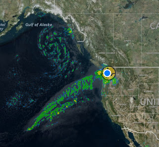
Update (Sat 12/21/2019):  Snoqualmie River near the Falls crested about 8 pm last night (Friday) @ 22,830 cfs.  It was evident  by Thursday night the  atmospheric river of moisture with this potent December storm had shifted further north than initially expected, aiming the fire hose directly at the Puget Sound region, pulling in warmer air with it, and increasing snow levels to around 4,000ft, compounding the river flow problem given heavy rainfall even at higher elevations.   Originally published 12/19/2019 12:55 PM Here come's the highly anticipated atmospheric river! Note the yellow circular graphic behind current location (below) isn't showing intense showers, but the small earthquake recorded this morning, a 3.4 magnitude near Fall City and one of three small quakes in the area over the last 24-hours. Those traveling across the passes should be prepared for periods of heavy snow and possibly even temporary closures for  avalanche control  Thursday afternoon i

Fog to blow out of Snoqualmie Valley soon; little rain, but relatively quiet weather until mid-December

Image
Visibility really dropped on Wednesday, December 4th, as the fog rolled in.  You can see why this happened (from the chart below) – as the day rolled on temperature and dew point nearly converged. Wunderground weather station (KWASNOQU33) from Snoqualmie Ridge  Fog can begin to form when the difference between air temperature and dew point is less than ~4° F.  Water vapor condenses into tiny liquid water droplets that are suspended in the air. I was driving through downtwon Snoqualmie last night and the sky looked eerily red and gray, like something out of Stranger Things. I gathered it was due to reflection off water vapor from the mix of Christmas lights in the surrounding area, as well as the field lights that were on at Mount Si High School.   The fog also made for some really cool Christmas light reflections in my neck of the woods. As for the rest of the week, another pressure gradient should form over the Cascades bringing back our beloved Snoqualmie Valley gap win

Cascade Gap winds kick up Saturday night, light snow possible Sunday

Image
Windy Saturday into Sunday. .. Higher confidence that a Low will move into proximity off the coast Saturday setting up an East-to-West pressure gradient that should kick up howling Cascade gap winds later Saturday into Sunday morning, at the peak of it probably gusting 40-50 mph at times in the Snoqualmie/North Bend vicinity.   Wind Gust map for W. WA overnight 11/30/19 Possible light snow Sunday, but more likely to just remain dry vs. Puget Sound… Incoming moisture from the southwest over the cold air already in place is often a recipe for snow, however Western Washington is only expected to get grazed with precipitation Sunday, with the brunt remaining offshore of the Oregon coast.  Southwest WA, parts of Kitsap County and even the I-5 corridor (including Seattle) may see brief accumulations before turning to rain.  Out here, we’re higher in elevation and we generally get more precipitation, so better chance for us to see the white stuff, right?  Not likely this time around. 

Snoqualmie Pass finally gets some needed snow; colder Thanksgiving temps on way for Snoqualmie Valley

Image
Snoqualmie Pass was finally getting some much needed snow Sunday night into Monday morning, November 24th.  The mountain passes are expected to receive  6-12” through Tuesday. The foothills are on the fringe for possible snow later Monday into Tuesday morning, but odds have diminished. The atmosphere will be drying out fast as the cold air moves in from the north, but if a typical north puget sound convergence zone setup shifts southeast, it’s possible to see a trace-2” in the foothills of Snoqualmie and North Bend – though this is looking less likely with almost every model run the past few days.  The Euro model’s mean ensemble run shows maybe flurries/dusting overnight Monday into Tuesday while GFS now calling for completely dry by the time cold enough air arrives.   University of Washington WRF-GFS 4km resolution forecast. Right scale showing 24-hr snow accumulation (in inches) as of 4pm Tuesday We’re transitioning to a flow from the north, ushering in modified arctic ai

Nov 5th marks earliest in season for 1"+ of snowfall at Snoqualmie Falls

Image
This day in 2017 (Nov 5) Snoqualmie Ridge received 2-3" of snow.  11/05/2017 @Snoqualmiewx Couger Mtn-Bellevue 4-6" dumping.  From Cougar mtn at an elev of 1,350ft, 5 days later! Nov 10th 2017 In fact this date marks the earliest in the season ever for accumulated snowfall (1.0") recorded at the official NWS Coop Snoqualmie Falls weather station (looking at records back to 1945) Fast forward to our current 11-day dry spell ☀️ .. aside from some minor gap winds that should kick up tomorrow night, rain chances keep getting pushed back. Latest model runs showing maybe a light shower this weekend, with chances for any significant precip more likely early next week.                

Largest October flood event on record for Snoqualmie River

Image
After 9.1" of torrential rain fell over the last 3 days in the mountains (as observed at Snotel-Olallie Meadow near Snoqualmie Pass) led to major flooding in Snoqualmie Valley,  how did  river flow end up ranking historically? Today's peak flow, measured in cubic feet per second (cfs), near Snoqualmie Falls ranked 14th all-time (based on historical NWS data back to 1959). Photo taken by Daniel Scott @GeomorphDan The only earlier in season I could find over the threshold of what's considered a 'major' category flood (~41,000 cfs), ranking in at #20 was 10/16/1988 at 40,400 cfs Also notable, 2015 had three independent flooding events!  Only 1975 (2) had more than one in top 20. Data: NWS Provided by City of Duvall

Line ’em up: Pacific storms roll through Western Washington over the next week

Image
Right on schedule for this time of year.   As is often said, October comes in like a lamb, goes out like a lion. Yesterday (October15 th ) marked the last day for the next six months the average high temperature exceeds 60°. This is based on 75 years of weather data taken at Snoqualmie Falls (Western Regional Climate Center). Here are the seasonal breakpoints: Even though wind advisories are not currently issued for the East Puget Sound Foothills this week, I am watching one higher resolution model (ECMWF or Euro) that shows gusty southerly winds out here peaking in the 40-50 mph range for Thursday evening, and again during the day on Saturday, as well as potentially Monday morning.   With a lot of leaves still on trees it wouldn’t take super strong winds to snap branches and potentially make a mess of an otherwise just soggy situation. This post was edited by  Living Snoqualmi e

Chances for a normal-ish winter have increased!

Image
The warm blob of water off our coast, that threatened a snow deprived winter for the mountains, has weakened significantly since late summer. Our chances for a normal-ish winter have increased!

What we might expect this Winter

Image
Cold and snowy this winter? As always, it’s quite the speculation . I’ve been noticing building expectations for another cold and snowy winter.  Not only is Snowmaggedon still fairly fresh in memories, we had a rather cool summer (by my count only one day above 90°, we average 5+ days each summer) and forecasts now are talking about snow this weekend across high terrain over the Western US and Canada. Highs near Pullman and Spokane may struggle to reach mid 40’s this weekend… a ~20° drop from mid-week. Brr! for late September.   But can the recent past and present paint us a good picture of what to expect for the upcoming fall/winter storm season? Most people realize weather forecasting out more than a few days seems to be a total crapshoot. Sorry, weather modeling hasn’t come that far (yet). Here was NOAA’s 90-day outlook as of mid-November last year.  As seen below, they were predicting above average temperatures (Reds) last winter. We all know how last February turned

Improving weather and clocks forward should make for good timing to view a few sunrises over the Cascades!

Image
As we move towards just boring old rain or sunshine for at least the next 7-8 months, let's talk for a minute about the Sun and all its glory and beauty! Looking East - Eagle Pointe, Snoqualmie  We set the clocks forward an hour tonight so the sun will rise one hour later tomorrow (7:30 am).  Weather pending, we might be able to catch some nice sunrises in the coming days and weeks,  hopefully beginning with Sunday morning.  Not too early on a weekend, right?  That used to be 'early' before kids:) Looking East - Douglas Ave, Snoqualmie According to over 100 years of NWS data, the odds of rain for our area from mid-March to mid-April are 55-60%; and figure odds of cloud cover on the eastern horizon at sunrise is quite a bit higher.  Not exactly odds worth waking for, but if you are up.. have a look East. In about a month from now (4/8), the sun will again be rising at ~6:30 am, or the same time as this morning (3/9 pre-clock change). On the first day of summer/lo

Wet snow back in the forecast

Image
Well I was hoping to tell you not to expect any snow arriving tomorrow evening, after all it is March, but the storm track appears to be in a Goldilocks position, making landfall to our SW (OR/CA border) to send bands of moisture our way while not scouring out enough of the cold air still flowing in from the north.  An elevation event for sure and light easterly winds that would have a drying effect are expected to turn southerly upon arrival of moisture, allowing for near full precip potential.  Not a direct hit by any means, but the potential to get messy. For a base-case scenario I'm expecting 1-3" of wet snow @ elevations 500-1,500 ft in the Cascade foothills beginning 3-6pm Wed through overnight. If the storm track comes in just a bit further north than expected, that should bring with it enough warm air aloft to keep the snow only in the mountains. Will update again tomorrow Update 3/6 1:45 pm... Not seeing much change in the pattern so I'll stick with m

Snow recap for February

Image
Here's my snow recap for February 2019. The 36" that fell over 10 days (varies widely by neighborhood) almost certainly holds a multi-decade record for accumulated base at any one time. Even edging out the 35" I had tallied from the entire epic winter of Dec'08-2009, including a slushy 1" on tax day (4/15/09).

Dry but Windy this weekend..

Expecting dry but windy for a large part of the weekend ahead for Snoqualmie and North Bend. Gap winds (~30-40 mph) look set to return by Saturday evening as a low organizes off the coast pulling on higher pressure east of the mountains. It isn't a deep enough low like the one that helped to really rev up winds on Valentine's Day (55+ mph). Models show other gap wind foothill communities, e.g. Enumclaw, Black Diamond and Columbia Gorge may see gusts a bit stronger, perhaps ~50 mph.

Snow chances for tonight diminishing..

Weather update (Wed 1:20 pm)... Chances for a little snow in the foothills tonight have weakened somewhat since this morning's models runs. Now only the Euro expects anything at all (still less than 1").  Otherwise we look to remain mostly dry the next several days but very cold for this time of year.  I'll update if I see any material changes to this forecast February will likely mark the coldest month in 28 years. 😨

Looking good for back to school after 2-week winter break

Image
There may still be pockets of flurries out there this evening but by now even your iPhone weather app should be giving the  👍  for Snoqualmie and North Bend weather for the foreseeable future.  Similar to this morning’s update, models are all still in agreement for any material snow threats to remain well south (Oregon, maybe SW Wa) tomorrow and quite possibly dry, other than a few flurries, the rest of the week.  There may be some eaterly gap breezes a t times this week in response to offshore storms, but not in ideal proximity to really kick winds into gear. I’ll update if I see things take a turn. Hope everyone had a nice (or at least tolerable) extended winter break! Judging by the Brown Bear lines today I’m not the only one taking the ‘under’ bet on inclement weather this week:)

After latest model runs Sunday morning, kids might go back to school after all!

Areas of scattered light snow showers falling this morning. Not much if any accumulation expected. The main snow potential forecasters have been watching (snow for late Sun/Mon) still appears to be heading well south of us with a storm track making landfall in south/central Oregon.  Dare I say it, but the kids might finally be heading back to school tomorrow! 😃 I don't expect much of anything as far as precipitation goes as all models are now e ssentially in agreement on this, but I'll take another look later afternoon/evening. Extended outlook (subject to greater uncertainty): Storm track appears to remain well south for the coming week, which aside from little snow potential, also means not likely to see more than just breezy conditions from our gap winds. We remain very cold seasonally. For Friday-March 1st I'm not sure we'll crack 40°. While warmer than recent days, that would still be 12° below the normal daily high. Baseball season is right around the corner 😨

Elevations - Eastside Foothills

Image
With recent fringe snow events there's been some chatter on threads regarding local elevations. I thought it was worthy of a post, building on some past work I've done to rank some notable Eastside foothill locations by max elevation (in feet) above sea level. Additions I've missed are welcome! The source I've used is King County's iMap feature which incorporates a digital ground model constructed from LIDAR (light imaging detection and ranging) data. Basically laser measurements of distance above sea level taken from aircraft surveillance. There are also several free GPS apps that probably get close enough (+/- 50 ft).

Snow looking to stay well south of us for Monday

Weather update-Saturday 8:30 am  It’s still early in forecasting snow potential for Sunday into Monday, but the latest model runs have backed way off, with only the Euro runs showing Snoqualmie/North Bend getting any precipitation at all. The situation further south (e.g. Portland) looks more daunting Monday. This obviously could change markedly based on storm track and will take another look tomorrow morning. Still have bread and milk ?

Snow showers this afternoon possible, 0-2"

We may see light snow showers this morning, then a heavier mix possible this afternoon and into Saturday. Because the air is likely to remain above freezing I’m only forecasting 0-2” for higher elevations in Snoqualmie and North Bend over next 24 hours. I’m watching a better chance for accumulating snow Monday, as well as keeping an eye on a potential windstorm late Tues/Wed. Will update as we get closer. A transition out of this cold rut doesn’t look to occur in February.

Lot's of moisture, maybe not cold enough for snow, but watch out in case!

We’re at the eve of yet another threat for snow in the foothills. Tomorrow through Wed morning at elevations ~500-1500ft (covering lower Snoqualmie/North Bend up to higher elevations of Eagle Pt., Wilderness Rim and Tiger Mtn/SR18), depending on the model run I’m expecting anywhere from 0-8” of wet snow accumulation. How’s that for conviction! The tricky part is all areas are expected to remain just above freezing during precipitation with a W/SW wind aloft. Lot’s of moisture providing lots of snow for the mountains. But no frigid Frazier outflows or chilling east gap winds for the foothills like a week ago that kept snow from changing to rain.

Wet snow possible, temps right on the bubble

Models indicating potential for 1-3” of wet snow ~Wed. Temps right on the bubble (rain vs. snow) though. Next weekend possibly another snow event, but much higher uncertainty.

Valentine's Day Wind!

As expected the cascade foothills (including susceptible communities from Gold Bar to the Columbia Gorge) had quite the gap wind event today. For Snoqualmie and North Bend, notable easterly winds arrived late last night and peak gusts arrived right on schedule this morning (~6 am). NWS finally came out with an ex post Wind Advisory about 6:15 am, but our top winds (~45-55 mph) had come and gone by then. Conditions still remained very windy all day with  gusts frequently reaching 40 mph until afternoon. As it turns out, today's wind event was likely the second strongest of our 2018/2019 stormy season so far. Here's the unofficial top ranked as monitored from a few personal wunderground anemometers located around Snoqualmie Ridge (tried to weed out extreme readings): Date Gust Direction 01/08/19 58 mph E 02/14/19 56 mph E 01/06/19 53 mph S 01/16/19 47 mph E 01/11/19 47 mph E 12/20/18 46 mph S There were no reported power outages that I could tell from PSE's map, likel

New daily snow total set for Snoqualmie Pass!

NWS just reported Snoqualmie Pass set a new daily record for snowfall on February 12, 2019 when 31.5" of snow fell.

High wind watch!

Looking at the latest model runs, my prior **High Wind Watch** calling for 40+ mph gusts may be too conservative. I now see substantial agreement for gap wind gusts tonight 45-55 mph. Timing has pushed a bit later, with peak gusts likely ~6 am Thursday, but expect strong E/SE gusts late tonight through morning tomorrow.  The winds should be triggered by a fairly potent low dropping down from the gulf of Alaska and e ventually track into central Oregon, just grazing us. That's the right setup to begin pulling on high pressure from E. WA. From a precipitation stand point, not much. It also isn't going to draw in super cold air from the Frazier B.C. gaps, but cold enough for slight chance of light snow. Longer range, NWS now thinks snow levels will be around ~1,500 ft into this weekend which would keep the threat of snow in the foothills to a minimum. This of course may change as we do look to stay much cooler than normal for mid-February and given that it's difficult to rule

After major dumping of snow, atmosphere finally drying out

NWS still has an advisory up until 10 pm for East Puget Sound Lowlands - up to 3" more snow possible. I think they're finally erring on the conservative side for us 🤔 . After reviewing the radar however, the atmosphere looks to finally be drying out. It's been a long stubborn process. Wet snow mixed with rain through much of today. I don't think poor Wilderness Rim in North Bend ever did switch over to rain 😨 . Overnight I expect rouge showers, poss ibly as wet snow, but with light south easterly winds and cloud cover we should stay above freezing all night, so I don't expect more than a little extra slush come morning. Wednesday should be mostly dry. For Thursday I'm going on **high wind watch** with gap wind gusts to 40+ mph. Looking like early morning hours Thurs. You may be woken if you have vinyl windows with a bedroom facing east. Our house sounds like a creaking ship when these winds howl. The winds we'll be triggered by a fairly potent low

Historic snowfall, a bit more to come today

NWS has extended a Winter Weather Advisory for the East Puget Sound lowlands until noon above about 500 ft for an additional 1-3" possible. Winter Storm Warnings continue into the evening for the mountains with no ETA yet on I-90 from Ext. 34 to Ellensburg reopening. Snoqualmie Pass is measuring snow accumulation in "feet" of course. Higher elevations like Wilderness Rim or Eagle Pt.-SR may not switch over, just run out of precipitation..eventually. Most sho uld see a transition to periods of light rain or no precipitation this afternoon. Gap winds let up overnight and light southerly breezes have taken over. That should greatly help to usher in warmer air aloft. As expected, appears to have snowed for most, if not all of the overnight period. Depending on exact spot, 24 hr snow totals at noon are likely to be in the 12-18" range. Wow! One for the ages. I was up here during Dec'08-early 2009 epic snowy winter. We tallied ~30" that entire winter. Feb-1