December storm to soak Snoqualmie Valley, bring heavy snow to mountain passes through the weekend
Update (Sat 12/21/2019):
Snoqualmie River near the Falls crested about 8 pm last night (Friday) @ 22,830 cfs. It was evident by Thursday night the atmospheric river of moisture with this potent December storm had shifted further north than initially expected, aiming the fire hose directly at the Puget Sound region, pulling in warmer air with it, and increasing snow levels to around 4,000ft, compounding the river flow problem given heavy rainfall even at higher elevations.
Originally published 12/19/2019 12:55 PM Here come's the highly anticipated atmospheric river!
Those traveling across the passes should be prepared for periods of heavy snow and possibly even temporary closures for avalanche control Thursday afternoon into Friday as rising temperatures and strong winds are expected.

Snoqualmie River near the Falls crested about 8 pm last night (Friday) @ 22,830 cfs. It was evident by Thursday night the atmospheric river of moisture with this potent December storm had shifted further north than initially expected, aiming the fire hose directly at the Puget Sound region, pulling in warmer air with it, and increasing snow levels to around 4,000ft, compounding the river flow problem given heavy rainfall even at higher elevations.
Originally published 12/19/2019 12:55 PM Here come's the highly anticipated atmospheric river!
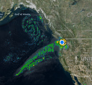 |
| Note the yellow circular graphic behind current location (below) isn't showing intense showers, but the small earthquake recorded this morning, a 3.4 magnitude near Fall City and one of three small quakes in the area over the last 24-hours. |
Those traveling across the passes should be prepared for periods of heavy snow and possibly even temporary closures for avalanche control Thursday afternoon into Friday as rising temperatures and strong winds are expected.

Find the full write-up published by Living Snoqualmie here
Comments
Post a Comment