Posts

Showing posts from September, 2020

The Week Ahead – Here Come’s the Sun, but will the Smoke Stay Away?

Image
Update: Wednesday 9/30/2020 6:43 am Starting day with better air quality than yesterday.  Light easterlies overnight have kept fog away.  Winds shift this morning and expect the smoke aloft to move overhead by mid afternoon. Mixing to surface light, AQI not expected to exceed moderate (yellow). Original post What a wet start to Autumn. While we didn’t tally anywhere close to the ~8 inch monthly precipitation record (at Snoqualmie Falls) for September, it did rain 4”.  That's the third wettest over any 3-day period in September.  Had it not been for the dry first three weeks of the month we might have threatened the monthly rainfall record.   Now let us talk about the big warmup on the way!   A building ridge of high pressure should dominate, potentially sending highs into the 80°’s by mid-week. With October fast approaching, this does beg the question if we’re going to break any heat records this week.  I was initially surprised by my finding.   Not Likely.  Turns out there was a m

The Week Ahead - Want Rain? Careful What You Wish For

Image
Update - 9/22/20: We're bracing for first major storm of the season as it pushes onshore Wednesday morning.  Lot's of wind and rain.  In fact, per Euro and NAM latest main model runs, I'm upgrading our wind gust prospects Wed afternoon and Fri inland, 30-40 mph+ gusts out of the S/SW possible in Snoqualmie Valley vicinity. With all the leaves still on trees, there may be intermittent power outages.    A second round of atmospheric river should develop over the weekend, keeping things wet.  By weeks end, we're talking potential 5+" of rain for late September! weather.us Longer range still hints and pulling a complete 180° next week with unseasonable warm and sunny weather.  Looking forward to that! Original story - 9/20/20 Now that we've all taken that deep breath of fresh air, more active weather is wasting little time arriving at our doorstep, and just in time for the first week of Autumn.   Autumn begins Tuesday, September 22nd , when the Sun crosses the cele

The week ahead – Blue Thunder may not be the only rumble heard

Image
A thunderstorm rolls through Snoqualmie last May Well I sure was envious looking at that 85° sunshine on the TV set this morning. Go Hawks! Fortunately, relief should be near for our current smoke situation.   Smoke was barely thinning aloft to end the weekend.   I noticed a sun almost too bright too look (at times), and it didn’t totally disappear after 10 am like yesterday, so that was a plus I guess.   Cough cough.. While air quality is still terrible and smoke remains trapped at the surface, we should slowly improve tonight, with the positive trend continuing into Monday and Tuesday. As an upper ridge shifts inland Monday, an increasingly moist SW flow may bring a few showers Monday into Tuesday, though models have backed off as far as getting much if any precipitation.  Still, stronger onshore push associated with this frontal system should help to clean up the air quality. We will be in between frontal systems Wednesda

Air Quality Alert issued - smoke from OR fires moving north through the weekend :(

Image
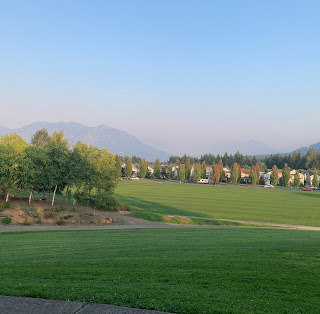
NWS is out with an Air Quality Alert  for most of Washington state through Monday at 11am.  At which point we should finally get a better onshore push and possibly some actual rain early next week! We will also start a cooling trend Friday so those that have been leaving windows shut should get some relief from the unseasonably warm weather that has reached into the low 90°‘s the last couple days. Pictures taken at Snoqualmie Community Park from Kite Hill area - Aug 17 (top), Sep 9th (bottom) Just as we were hoping the smoke (from E. WA) would be bugging out of here due to the shift in expected winds later today (Thursday), it will unfortunately soon be replaced by potentially more substantial wildfire smoke from Oregon due to southerly winds:( NOAA/NWS GOES-17 satellite image 09-09-2020 Relatively speaking, our current air quality is the best it’s been since before the east winds brought over smoke Monday evening.  Still at levels considered unhealthy for sensitive groups. But save fo